

Location
UNIMORE is spread over the two cities and has a polycentric campus structure. Of the 14 departments, 11 are in Modena and 3 in Reggio Emilia.
Location of the cities
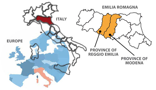 Situated in the heart of the Emilia Romagna region, Modena and Reggio Emilia are an important link between Northern and Southern Italy and between Italy and the rest of Europe. The cities are only 19 km apart and connecting trains run approximately every half hour.
From Modena and Reggio Emilia, one can reach Milan in under two hours, Florence in an hour and a half, and Rome in three and a half hours. The Bologna airport, situated 39 km from Modena and 58 km from Reggio Emilia, serves all the main national and many international routes. The other international airports closeby, Linate and Malpensa and Orio al Serio, are around Milan.
The Romagna Riviera, famous throughout Europe for its beaches and night clubs, is only an hour and a half by car or train. Those preferring the mountains can enjoy the 50 km of ski trails in Monte Cimone, the largest ski resort in the Northern Apennines. In addition to skiing, the Apennines (see www.appenninomodenese.net and www.appenninoreggiano.it) offer excursions, fun and relaxation, and are only between half an hour and an hour from Modena or Reggio Emilia.
| Distance to other cities | Modena | Reggio Emilia |
|---|---|---|
| Reggio Emilia | 19 km | - |
| Modena | - | 19 km |
| Parma | 47 km | 30 km |
| Bologna | 39 km | 60 km |
| Ferrara | 80 km | 80 km |
| Brennero | 320 km | 330 km |
| Venice | 200 km | 220 km |
| Milan | 170 km | 150 km |
| Florence | 130 km | 150 km |
| Rome | 410 km | 430 km |
| Distance to airports | Modena | Reggio Emilia |
|---|---|---|
| Bologna | 39 km | 56 km |
| Florence | 130 km | 157 km |
| Verona | 90 km | 130 km |
| Milan Linate | 170 km | 150 km |
| Milan Malpensa | 230 km | 205 km |
| Milan Orio al Serio | 200 km | 190 km |
| Parma | 50 km | 35 km |
Departments and schools located in Modena
Departments located in Reggio Emilia
Click here for an interactive web page showing you the location of the university's structures and facilities on local maps.